|
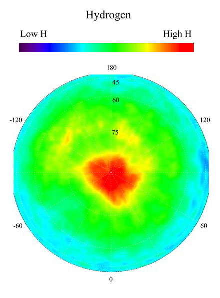
Map of Martian Polar Hydrogen
This gamma ray spectrometer map centered on the north pole of
Mars is based on gamma-rays from the element hydrogen. In this
region, hydrogen is mainly in the form of water ice. Regions of high ice
content are shown in red and those low in ice content are shown in
blue. The very ice-rich region at the north pole is due to a permanent
polar cap of water ice on the surface. Elsewhere in this region, the ice
is buried under several to a few tens of centimeters of dry soil.
The sub-surface ice is not uniformly distributed in the north, but varies
with both latitude and longitude. In the north, the soil is well over
50 percent ice, which is more than can be accommodated by just filling
the pore space in pre-existing soil. This high ice content implies that
the ice may have been slowly co-deposited with dust in the past when
conditions were wetter. Deposition of ice by this process means it is
more likely that the ice deposits are very thick and may even be deep
enough to have liquid water at their base.
NASA's Jet Propulsion Laboratory manages the 2001 Mars Odyssey
mission for NASA's Office of Space Science, Washington, D.C.
The gamma ray spectrometer was provided by the University of
Arizona, Tucson. Lockheed Martin Astronautics, Denver, Colo., is the
prime contractor for the project, and developed and built the orbiter.
Mission operations are conducted jointly from Lockheed Martin and
from JPL, a division of the California Institute of Technology in Pasadena.
Credit: NASA/JPL/University of Arizona
|