|
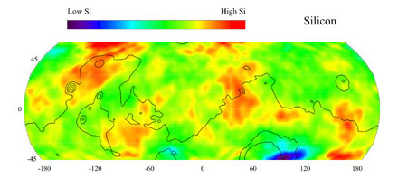
Map of Martian Silicon at Mid-Latitudes
This gamma ray spectrometer map of the mid-latitude region of
Mars is based on gamma-rays from the element silicon. Silicon is one of
the most abundant elements on the surface of both Mars and Earth
(second only to oxygen). The most extensive region of highest silicon
content, shown in red, is located in the high latitudes north of Tharsis
(centered near 45 degrees latitude, -120 degrees longitude). The area
of lowest silicon content, shown in blue, lies just to the east of the
Hellas Basin (-45 degrees latitude, 90 degrees longitude). Contours of
constant surface elevation are also shown. The long continuous
contour line running from east to west marks the approximate
separation of the younger lowlands in the north from the older
highlands in the south.
NASA's Jet Propulsion Laboratory manages the 2001 Mars Odyssey
mission for NASA's Office of Space Science, Washington, D.C.
The gamma ray spectrometer was provided by the University of
Arizona, Tucson. Lockheed Martin Astronautics, Denver, Colo., is the
prime contractor for the project, and developed and built the orbiter.
Mission operations are conducted jointly from Lockheed Martin and
from JPL, a division of the California Institute of Technology in Pasadena.
Credit: NASA/JPL/University of Arizona
|