| Elysium Mons Volcanic Region
On July 4, 1998---the first anniversary of the Mars Pathfinder
landing--- Mars Global Surveyor's latest images were radioed to Earth
with little fanfare. The images received on July 4, 1998, however, were
very exciting because they included a rare crossing of the summit
caldera of a major martian volcano. Elysium Mons is located at 25°N,
213°W, in the martian eastern hemisphere. Elysium Mons is one of three
large volcanoes that occur on the Elysium Rise-- the others are Hecates
Tholus (northeast of Elysium Mons) and Albor Tholus (southeast of
Elysium Mons). The volcano rises about 12.5 kilometers (7.8 miles)
above the surrounding plain, or about 16 kilometes (9.9 miles) above
the martian datum-- the 'zero' elevation defined by average martian
atmospheric pressure and the planet's radius.
Elysium Mons was discovered by Mariner 9 in 1972. It differs in a
number of ways from the familiar Olympus Mons and other large
volcanoes in the Tharsis region. In particular, there are no obvious lava
flows visible on the volcano's flanks. The lack of lava flows was apparent
from the Mariner 9 images, but the new MOC high resolution
image--obtained at 5.24 meters (17.2 feet) per pixel--illustrates that
this is true even when viewed at higher spatial resolution.
Elysium Mons has many craters on its surface. Some of these
probably formed by meteor impact, but many show no ejecta pattern
characteristic of meteor impact. Some of the craters are aligned in
linear patterns that are radial to the summit caldera--these most likely formed
by collapse as lava was withdrawn from beneath the surface, rather
than by meteor impact. Other craters may have formed by explosive
volcanism. Evidence for explosive volcanism on Mars has been very
difficult to identify from previous Mars spacecraft images. This and other
MOC data are being examined closely to better understand the nature
and origin of volcanic features on Mars.
The three MOC images, 40301 (red wide angle), 40302 (blue wide
angle), and 40303 (high resolution, narrow angle) were obtained on
Mars Global Surveyor's 403rd orbit around the planet around 9:58 -
10:05 p.m. PDT on July 2, 1998. The images were received and
processed at Malin Space Science Systems (MSSS) around 4:00 p.m.
PDT on July 4, 1998.
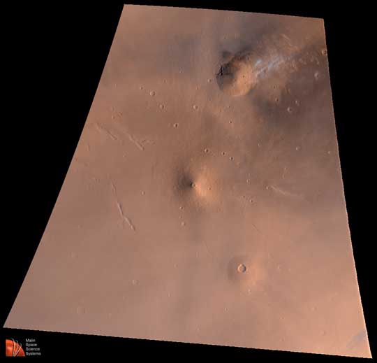
This image: Elysium Volcanic Region as seen by MOC on July 2,
1998. Volcano near top center is Hecates Tholus--note bright clouds
off its northeast flank. Volcano near center is Elysium Mons; volcano
toward lower right is Albor Tholus. Red channel is MOC red wide angle
image 40301, the blue channel is MOC blue wide angle image 40302,
and the green channel is synthesized by averaging the red and blue
bands. Image is an orthographic projection centered at 24.85°N,
213.25°W. The scale at the center of the projection is 4.65 kilometers
(2.9 miles) per pixel. North is up, illumination is from the lower right.
Malin Space Science Systems and the California Institute of
Technology built the MOC using spare hardware from the Mars Observer
mission. MSSS operates the camera from its facilities in San Diego, CA.
The Jet Propulsion Laboratory's Mars Surveyor Operations Project
operates the Mars Global Surveyor spacecraft with its industrial partner,
Lockheed Martin Astronautics, from facilities in Pasadena, CA and
Denver, CO.
Photo Credit: NASA/JPL/Malin Space Science Systems
|