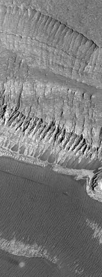
| Melas Chasma
One of the earliest observations made by the Mars Global Surveyor
(MGS) Mars Orbiter Camera (MOC) was that the upper crust of the
planet appears to be layered to considerable depth. This was
especially apparent, early in the mission, in the walls of the the
Valles Marineris chasms. However, layered mesas and mounds
within the Valles Marineris troughs were recognized all the way back
in 1972 with Mariner 9 images. The MOC image presented here
shows many tens of layers of several meters (yards) thickness in
the walls of a mesa in southern Melas Chasma in Valles Marineris.
Erosion by mass wasting--landslides--has exposed these layers
and created the dark fan-shaped deposits seen near the middle of 3
the image. The floor of Melas Chasma is dark and covered with many
parallel ridges and grooves (lower 1/3 of image). In the lower left
corner of the picture, a bright, circular dust devil can be seen casting
a columnar shadow toward the left. This image, illuminated by
sunlight from the right/lower right, covers an area 3 kilometers
(1.9 miles) wide and 8.2 kilometers (5.1 miles) long. The scene is
located near 10.1°S, 74.4°W and was acquired on July 11, 1999.
North is toward the lower left.
Photo Credit: NASA/JPL/Malin Space Science Systems
|