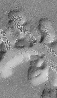
| Nirgal Vallis and its Windblown Dunes
Nirgal Vallis is a narrow valley system that stretches approximately 420 kilometers (260 miles) across the
martian surface near 28°S latitude, north of the large basin, Argyre. The floor of the valley system is largely
covered with light-toned dunes and ripples. These windblown features obscure most of the original
morphology of the valley floor. This view of a small portion of Nirgal Vallis was obtained by the Mars
Global Surveyor (MGS) Mars Orbiter Camera (MOC) during Extended Mission subphase E02 on March
29, 2001. In each short tributary valley, dunes have a somewhat different orientation compared to those in
the other valleys. The dune patterns here indicate that winds are locally controlled by the shape and
orientation of each valley. The dunes just left of the center of the image have small craters on them, formed
by meteor impact. The craters indicate that the dunes are not fresh, modern features, but are considerably
older than they might at first seem. This image covers an area 3 km (1.9 mi) wide and is illuminated from
the upper left.
Image Credit: NASA/JPL/Malin Space Science Systems
|